Prachuap Floods: What the Rain Means for Hua Hin Trips South
Gauges in Bang Saphan caught 300 mm of rain in six days; Hua Hin’s town gauge caught 36. Which stretches of Phetkasem Road were shut, what the forecast says, and what to check before driving south.

The rain gauge at Hua Hin’s municipal office collected 36 mm of rain between 26 and 31 October. A gauge at Ban Sai Khu in Bang Saphan, about 150 km to the south, collected 302 mm over the same days. That gap explains why Hua Hin got through the week with modest rain, while the southern half of Prachuap Khiri Khan province dealt with flooded roads, closed U-turns and residents in evacuation shelters.
The figures come from ThaiWater, the national water data system run by the Hydro-Informatics Institute, which pulls in readings from hundreds of gauges run by different agencies. The chart below takes the wettest gauge in each district. Every district from Thap Sakae southwards topped 249 mm, while the wettest reading anywhere in Hua Hin district was 66 mm, at Thap Tai, inland from the town.
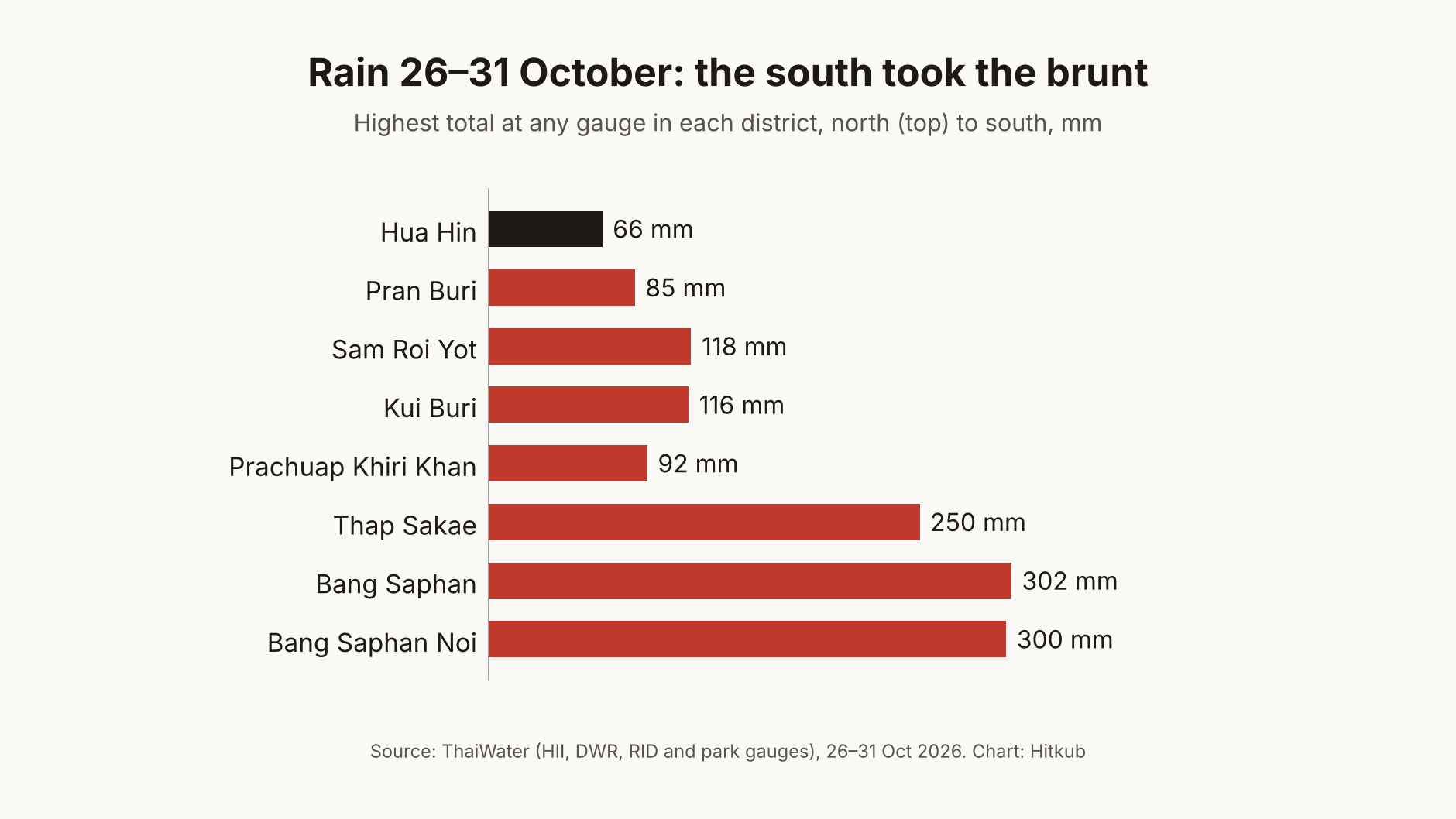 Chart: Hitkub. Data from ThaiWater (Hydro-Informatics Institute, Department of Water Resources, Royal Irrigation Department and national park gauges), 26–31 October 2026.
What the gauges show
The pattern runs almost in a straight line down the coast. Pran Buri’s wettest gauge recorded 85 mm, Kui Buri and Sam Roi Yot about 116–118 mm, and then the totals more than double in Thap Sakae. Bang Saphan and Bang Saphan Noi each had gauges near 300 mm, more than eight times the reading in Hua Hin town.
The worst of it came on 28 and 29 October, when Bang Saphan flooded, according to the provincial administration. By Sunday morning the rain had largely stopped. In the 24 hours to 11:00 on 1 November, the gauges at Hua Hin municipal office and the Thai Meteorological Department’s Hua Hin station both read zero. The wettest gauge in Bang Saphan logged 20.5 mm, ThaiWater’s data shows.
Residents told Channel 7 that Bang Saphan floods almost every year at the end of the rainy season. A video it aired on 30 October showed fast water close to the deck of a bridge. The water started to recede that morning, though Prachuap Khiri Khan’s irrigation project kept four subdistricts (Kamnoet Nopphakhun, Chai Kasem, Thong Mongkhon and Ron Thong) on alert for flash floods.
Where the road south broke
On the evening of 29 October, the Department of Highways’ disaster centre counted 14 damaged highway sites in six provinces, Bangkok Biz News reports. Ten had reopened and four were still impassable. Three of those four were in Prachuap Khiri Khan, and none was in Hua Hin.
Two of them are U-turn points on Phetkasem Road in Thap Sakae, at km 348 and km 358, where flooding and earth slips damaged the crossing. The notice covers the U-turns themselves, so drivers could not turn there, and it did not list Phetkasem’s main lanes as closed. The third is the first 500 metres of Highway 4372 in Bang Saphan, between the Wang Yao junction and the old Phetkasem road. The department said it could not yet reopen that stretch.
The provincial Highway District also measured standing water along Highway 4 that evening, as Hua Hin Localplus summarised. It found 10 cm at Sam Kratai in Kui Buri and 70 cm and 40 cm at the two Thap Sakae U-turns. Bang Saphan had 20 cm, and the U-turn under the Nai Samed bridge had 50 cm. Staff from its Hua Hin division went south to help monitor.
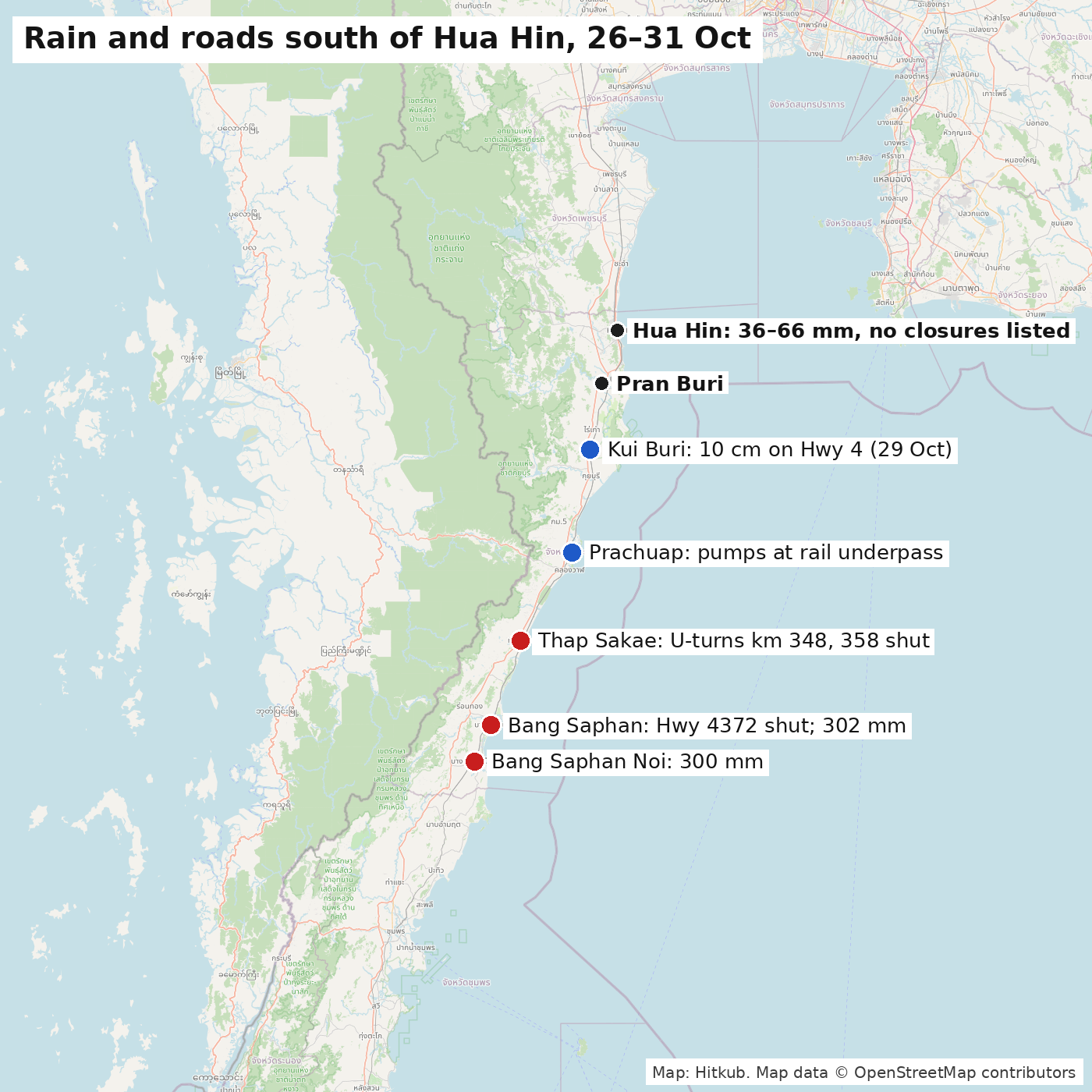 Map: Hitkub. Map data © OpenStreetMap contributors. Points are placed at district level. Road details from the Department of Highways and the Prachuap Khiri Khan Highway District (29 October); rain totals from ThaiWater (26–31 October).
Is it over?
Mostly, if the forecast holds. The Thai Meteorological Department expected heavy rain over the upper south to continue through Sunday 1 November, covering 40 to 70 percent of the area. It forecast the rain to ease from Monday 2 November, Channel 7 reports. The government’s own warning on 31 October named Phetchaburi, Prachuap Khiri Khan, Chumphon and Surat Thani, with flash floods most likely on slopes near waterways and in low ground, Thai Rath reports.
The Hydro-Informatics Institute’s 48-hour flood watch from 30 October covered parts of Thap Sakae, Bang Saphan, Bang Saphan Noi and Prachuap Khiri Khan city, plus districts in Chumphon, Thansettakij reports. No part of Hua Hin was on it. Relief work is now the focus. The province’s flood command met on 31 October to plan help for residents of Kui Buri, Prachuap Khiri Khan city, Thap Sakae, Bang Saphan and Bang Saphan Noi, Talk News reports. In Prachuap Khiri Khan city, the municipality has pumps working at its railway underpass, Localplus reports.
A practical checklist for trips south
Pran Buri and Sam Roi Yot, the destinations in our day trip guide, had less than half the rain of the southern districts and no listed closures. Beyond Prachuap Khiri Khan city, it pays to check before you go:
- Road status: the Department of Highways publishes live closures at hdms.doh.go.th and answers questions on its free 24-hour hotline, 1586, FM91 reports.
- U-turns: if you need to turn back in Thap Sakae, plan on a different U-turn than km 348 or km 358 until the department reports them open.
- Standing water: dips, U-turns and underpasses flood first. Don’t drive into water whose depth you can’t see.
- The sea: waves could top two metres where storms pass, Channel 7 reported, so check conditions before booking a boat trip in the next day or two.
Updated 1 November: added ThaiWater rainfall data, the Department of Highways closure list and the forecast. The Thap Sakae points are U-turn crossings rather than underpasses, and the closed Highway 4372 section is in Bang Saphan district, per the Department of Highways.
— End of article —